Product Reviews
PixelActive CityScape
by John HattanIntroduction
First off, what CityScape is and what it isn't. CityScape is a tool that allows you to quickly assemble and design detailed cities and surrounding terrains. It's not really a modeler as such. It's more a tool that lets you set up a realistic looking city by building an initial terrain and a rough outline of the roads. Then CityScape can "fill in the blanks" to build a city, right down to the traffic lights and road signs and telephone poles. As such, this is a very narrowly-scoped tool, and it's priced accordingly. While you could indeed build everything that CityScape can with a conventional 3D modeling tool, it's very unlikely that you could do it as quickly and realistically as CityScape can. Ultimately your "make vs buy" decision comes down to the time you'd need to hire a modeler. If you plan to have several cities in your movie/simulator/driving game, you'll need to take a 3D artist's time into account. And if this tool can successfully reduce the design time from a few months to a few days, then it's likely worth it.
Enough justification. On to the program.
Operation
Scene navigation in CityScape is quite simple, mostly reduced to "press the ALT key to navigate". Alt+left button will rotate your scene (okay, the camera) around. Alt+right button zooms. Alt+both buttons pans. The "C" key switches between your current camera and an overhead view, so it's easy to see how your plan view matches the perspective. Screen navigation was lightning-fast for me, without any noticeable hiccups or need to degrade down to low polys or wireframes. This program was made with designers in mind. It's also intended with close-up work in mind, because small polygon handles are difficult to grab when you're zoomed out so that your whole city is visible. As shown in the scene below, it's fairly easy to move things around with nice convenient handles on all the vector objects.
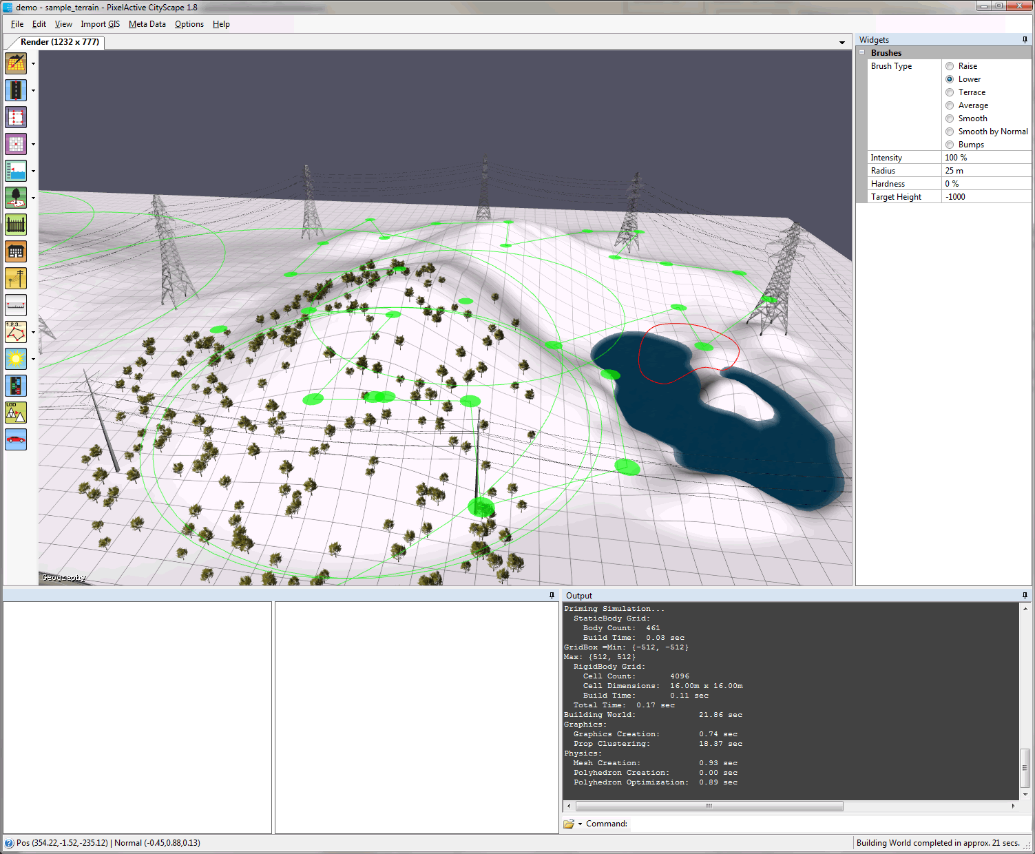
Terrain editing is fairly simple, and it can be done with as little or as much precision as you like. If you're building a generic "Anytown USA", you'll probably be just fine with the "Global Paint" tool, which allows you to "paint" hills and valleys on your plane just like a paint program. In the following example, that red circle that's draped over the right side my landscape is my paintbrush. In the "widgets" panel along the right, you see that I have it set to lower the terrain, and I'm using it to paint a pond. If you prefer thinking in vectors, you can build a terrain out of polygons and bounding circles that influence the ground plane under them, up or down. If you need something a little more realistic, CityScape has many different import options to pull in terrain. It has the standard bitmap-heightmap import, which is useful if you have an overhead map of a terrain that you want to convert to heights. Or if you have some standard format GIS info available, you can import it, thus getting true-to-life terrain and roads. It fully supports the OpenStreetMap format, which seems to be the standard place to get real streets nowadays.
Figure 1: CityScape showing off a little terrain I built, and to which I added some power poles, trees, and a lake.
CityScape's terrain tools are all vector-based and are procedural. If I, for example, drag around the bounding polygon that contains my trees, the trees would reposition themselves to fill the polygon. And all of this is done with quite a bit of rule-based computer intelligence. That means that trees and power poles won't end up in the lake. Towers build on level areas. That kind of thing. With just a little dragging around, you can build something that looks pretty reasonable and doesn't look like it was done by a computer programmer with no discernable civil engineering skills.
Once you've placed some terrain, roads, and locations for buildings, CityScape will fill in the civilization for you. You can choose the types of buildings to place, based on whether you want residential, light commercial, dense commercial, etc, and CityScape will procedurally "grow" the city to fit your specs.
If you have your own buildings, you can import them directly. CityScape supports COLLADA, which is the import/export standard that pretty-much every 3D modeling program supports nowadays.
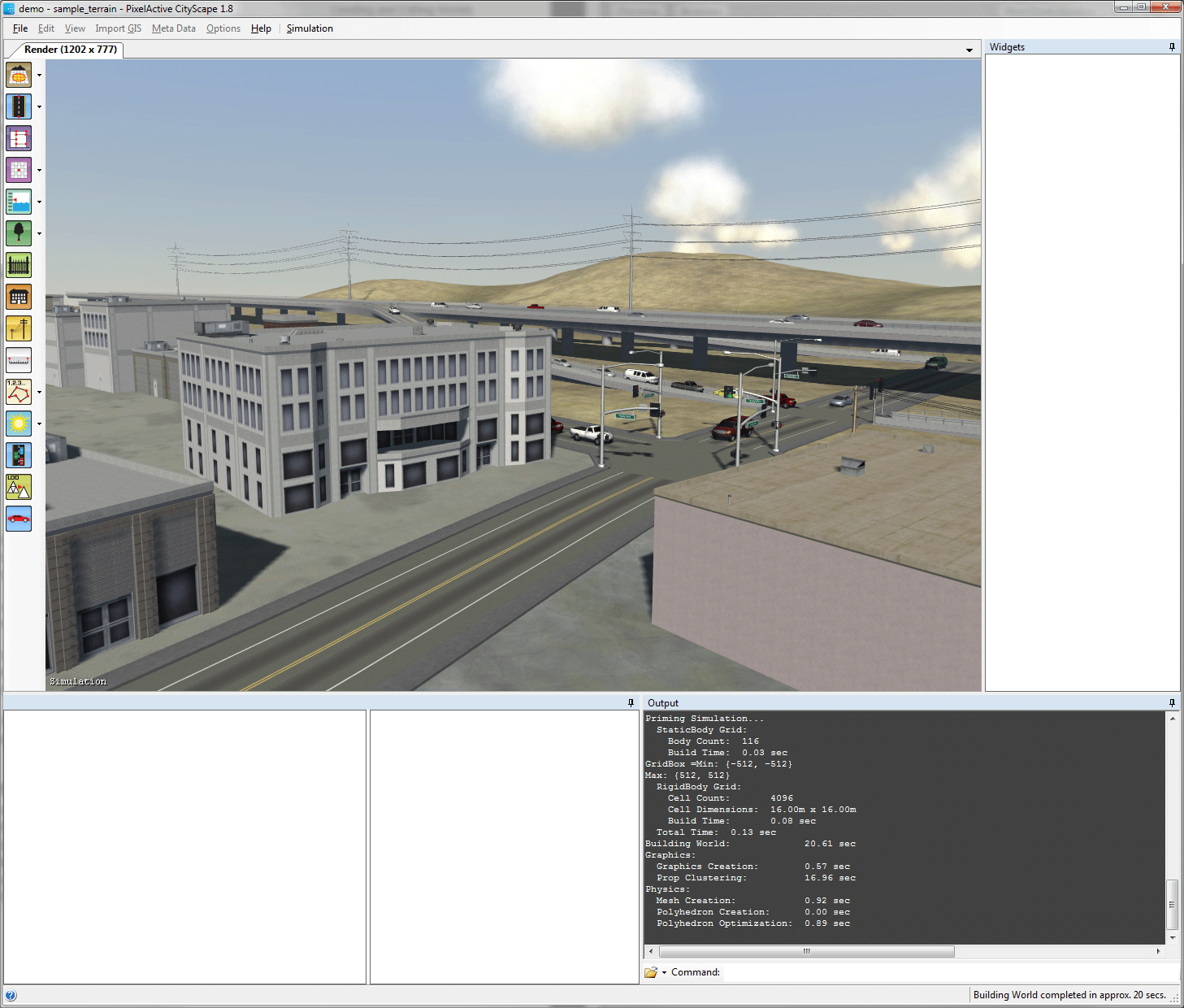
After the initial building placement, you can change up what's been generated. For example, this gray bank-looking building was originally placed by the program parallel to the road (same as its neighbor). Thinking I wanted things a bit different, I tilted the building out of the perpendicular, probably in violation of my fictional city's zoning laws as there's now not enough room for a sidewalk along the side. . .
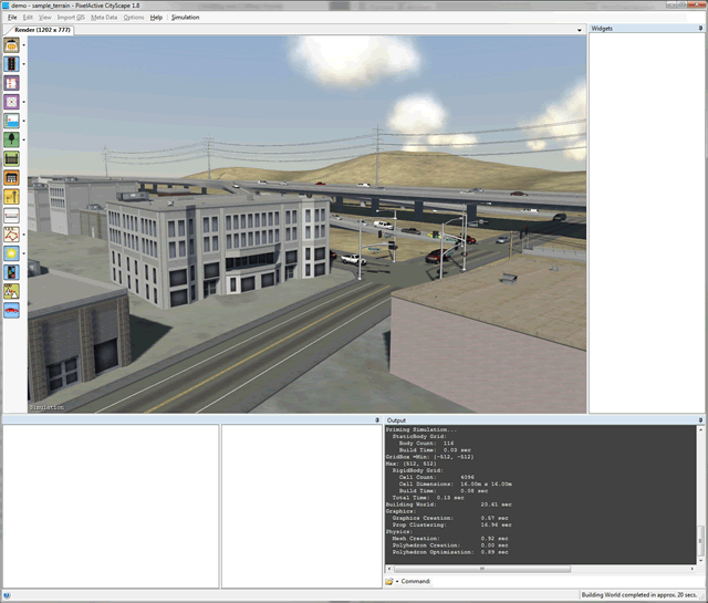
Figure 2: A scene happening "live" after I've moved an automatically-placed building.
CityScape's preview mode shown above is very detailed. While it's not obvious from the screenshot, the preview above is actually running live. Not only are the clouds moving and casting shadows on the ground, but all the traffic lights are working and cars are following the rules of the road, coming down from the exit ramp and turning at the stop light. Even the turn signals on the cars are blinking.
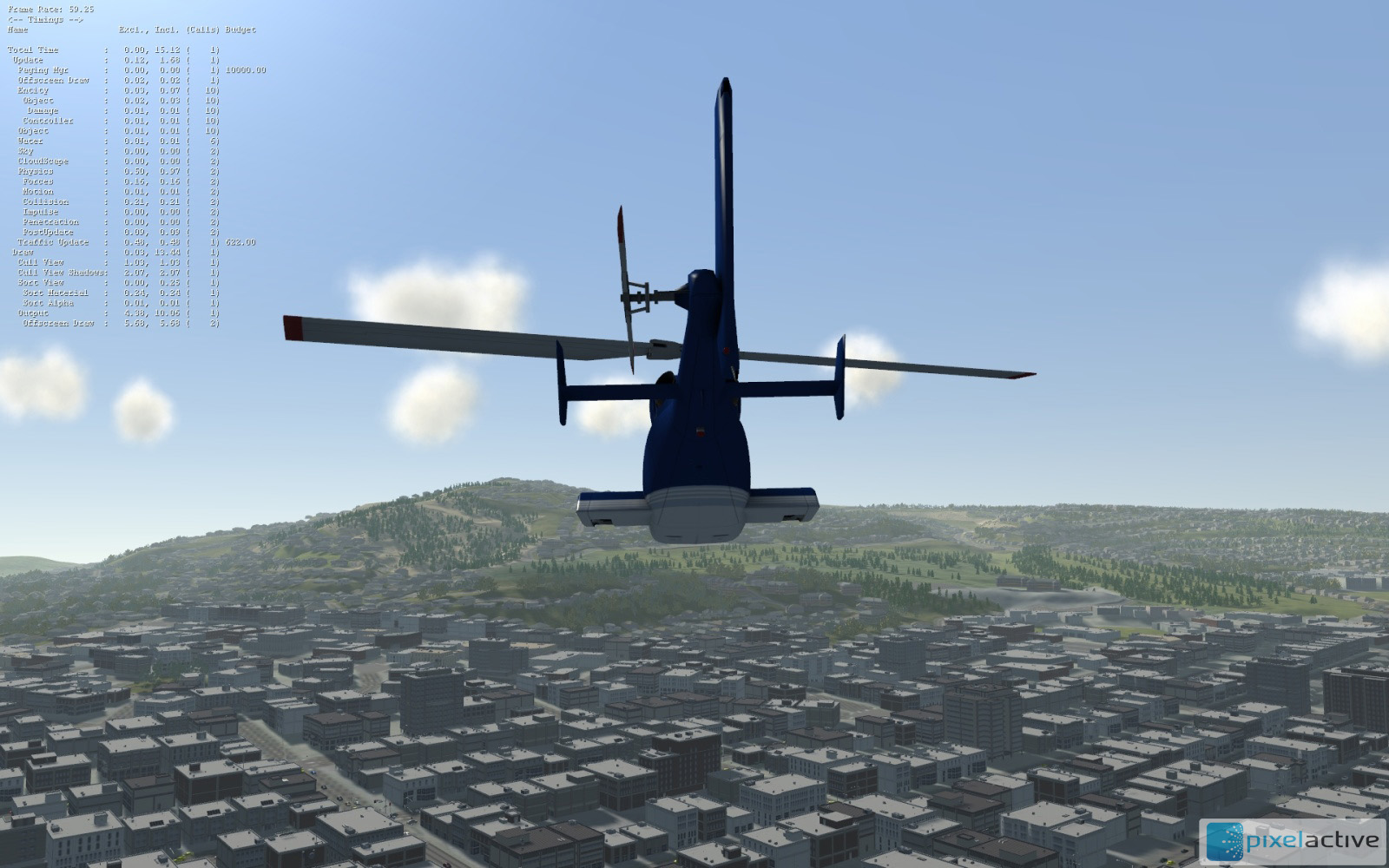
In addition to just panning around your "live" city with the mouse, you can do a drive-through or a fly-through with a helicopter or car. Doing this requires you have an XBox controller hooked up to your computer. I didn't have one handy, so I'm going to show off one of PixelActive's canned screenshots for this.

Figure 3: Flying over a generated city with the helicopter.
If you need to show off your handiwork to a client/producer/non-graphics-guy, the helicopter or car-mode would be very effective, as they show off the city in a familiar way rather than a CAD program's eye view. And, most likely, if you need cities this detailed, you're making a flying or driving game, and this is going to give you a good feel for how things will look in the actual game.
Instructions and Support
CityScape comes with a 250-page manual. The manual is well written and is up to date with the latest version of the product (1.8.3 at the time of this review). The "help" menu also links to five short tutorial movies on YouTube. Unfortunately, these movies appear to have been taken a minor version or two ago, referring to things that the latest version doesn't have, like the "mode" menu on the menubar which has apparently been replaced with CityScape's toolbar. In my case, the manual was enough to get started. CityScape comes with one sample terrain/city/lake, and the manual shows you how to work with this sample. It follows fairly easily, and the product is fairly easy to pick up.
As for support, this is a premium product, and it had better come with premium support. In my case, I had no problem getting my tech questions answered promptly.
Installation and General Hassles
CityScape is protected with a USB dongle, and the installation is fairly time-consuming. In addition to the standard SETUP.EXE installation, there are about three steps of back-n-forth you do with Pixelactive.com to enable the dongle and marry it to your copy of CityScape. It's time-consuming, but once you have the dongle enabled and properly married to your CityScape installation, you can forget about it until you need to move your installation to another machine.
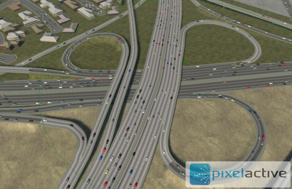
Figure 4: CityScape showing a pretty sophisticated highway interchange. There are plenty of videos and screenshots here.
I did encounter bugs with CityScape. CityScape is a .NET application, and the only reason I know that is because I received several complaints from the .NET JIT-compiler that something-or-other wasn't working properly and the whole program now going to shut down. These errors were being trapped by a bug-reporting tool that emailed back dumps and call-stacks back to the PixelActive mothership. Usually I'd get an email a few minutes later telling me what the problem was and how to fix it. Unfortunately, the fix was usually "reinstall the app". While reinstalling sometimes fixed the problem and sometimes didn't, you should be sure that PixelActive is on-call when it's crunch time for your project, as a crash in your build pipeline is, to say the least, a problem.
Conclusion
CityScape is a very narrowly-focused tool that solves a specific problem. And if you have a project where you need a city, for driving or flying, your choices are pretty limited and generally reduce to "hire a 3D artist for quite some time". CityScape could reduce this time significantly as well as give the producers an excellent way to preview the design via the"live" helicopter and/or car.
Just be aware that I encountered some problems along the way. If you pay a lot for a piece of software ($19,000 at the time of this review), you should feel that you're making an investment in the company. Software bugs are a fact of life. It's how the bugs are handled and how the toolmaker can work with your own development team/pipeline that's what makes the software worth the investment.